-
Sale!Out of stock

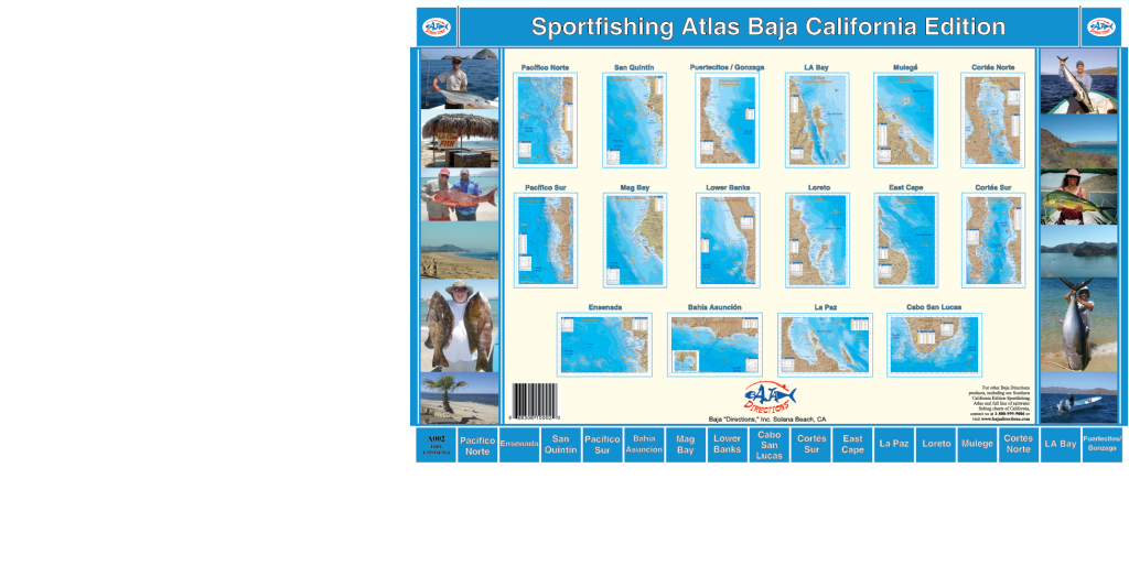
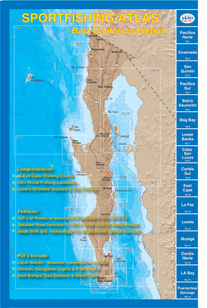
 Sportfishing Atlas Baja California Edition and Sportfishing Atlas Southern California Edition Atlases
 -
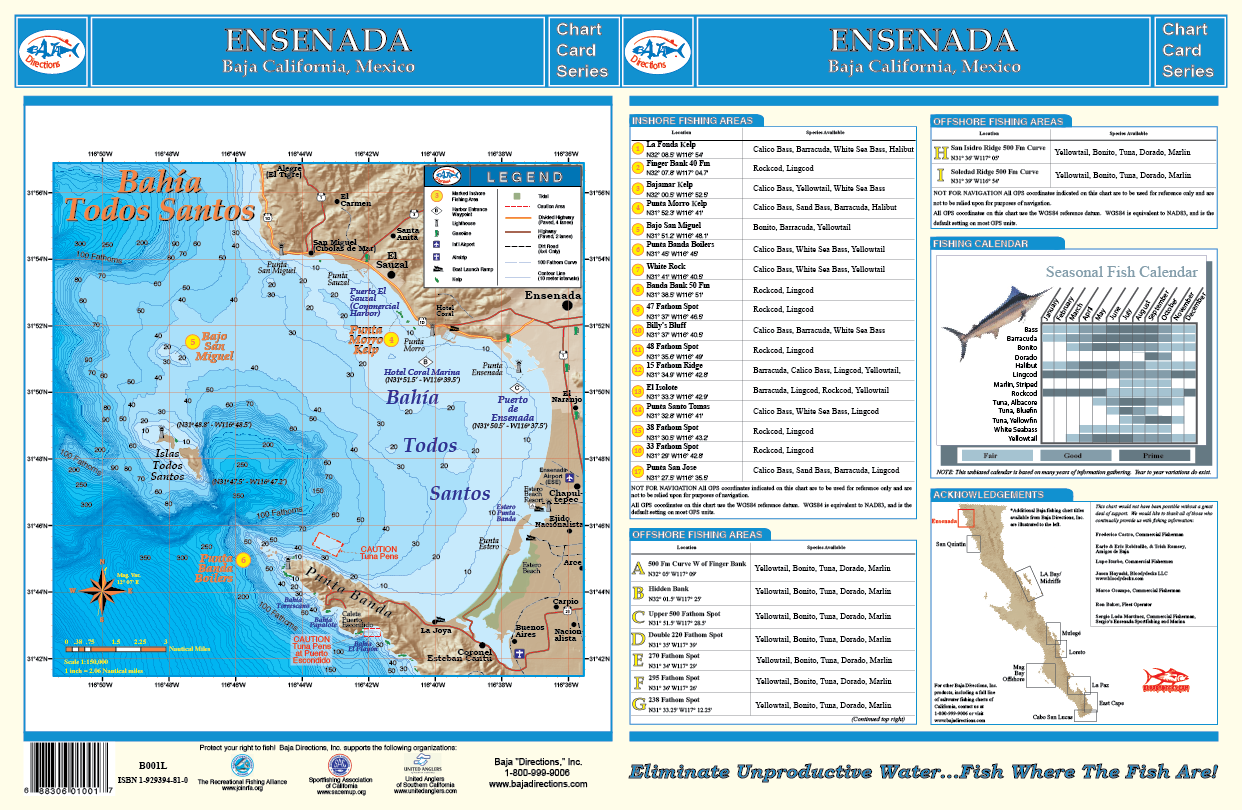
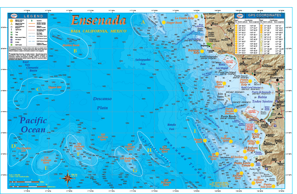 Our Ensenada chart covers the fishing areas from the kelp beds of La Fonda located just north of Puerto La Salina, to Punta San Jose to the south, a good hour's run down the coast from Ensenada. This chart features GPS numbers and locations of both offshore and inshore fishing areas such as the Hidden Bank, Upper 500 Fathom Spot, Banda Bank, Bajo San Miguel and the Double 220 Fathom Spot, as well as lesser known areas such as El Isolote and White Rock - small rocky islets jutting from the ocean's surface off Punta Santo Tomas and Punta Banda respectively. The underwater contours (bathymetry) of this chart were rendered from a private survey for natural gas and oil exploration and remain the absolute most detailed view of the ocean floor off Ensenada in existence! Also featured is a separate large-scale chart of Bahia Todos Santos that details out the harbor areas of Ensenada, including the popular Hotel Coral & Marina. This full color, high-resolution chart also features a seasonal fishing calendar which lists the best months for fishing by species and is currently available exclusively in our popular 11"x17" laminated format.
 -
Out of stock
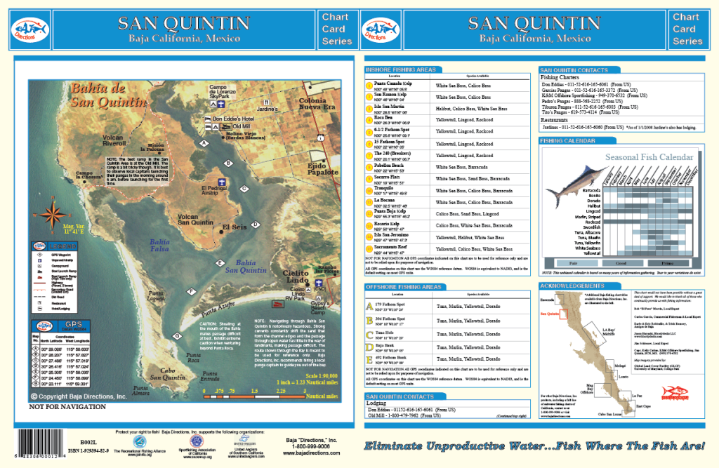
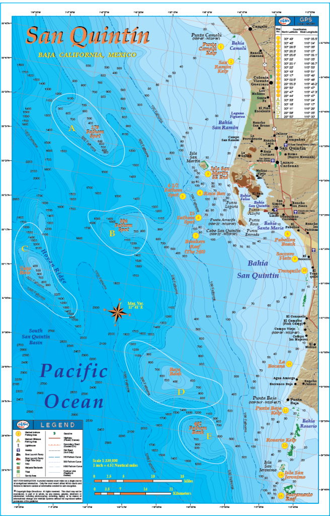 This chart is laminated and measures 11 X 17. We made quite a few changes from our original San Quintin title by shifting the focus of our chart to a larger scale and including the great fishing areas a full day boat ride to the south of San Quintin. This map encompasses the Baja coast from Punta Camalu to the north and Sacramento Reef to the south, including Isla Jeronimo, Punta Baja and Isla San Martin. The GPS numbers of prime bottom fishing areas like Ben's Rock, Breakers Reef (a.k.a. The 240), and the 61/2 Fathom Spot are featured on the chart, as well as the white sea bass areas of increasing fame such as Pabellon Beach, El Tranquilo and Socorro. Also included is a satellite image of Bahia San Quintin taken on an extraordinarily clear water day which distinctly shows the infamous channel in and out of the bay. We have also acquired GPS numbers marking the channel from a gentleman who has 30 years experience navigating through the bay! The positions of these GPS waypoints have been precisely overlayed on top of the satellite photo, giving you a frame of reference as to where in the channel each waypoint is. Baja Directions, Inc. still recommends hiring a local guide to get you safely in and out of the bay at least the first few times, but this incredible resource is a must-have for the experienced and first-timer alike as it will definitely shorten your learning curve. The locations of the most popular facilities in the San Quintin area such as the Old Mill, Don Eddies, Campo de Lorenzo sky park and more are also pointed out on the satellite image, making this chart a one-stop resource for the traveling fisherman.
 -
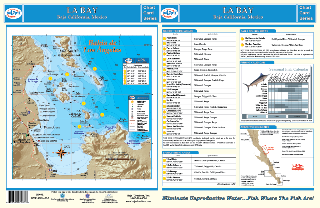
 This chart covers from Punta Final to the north, south to Bahia San Francisquito and includes the northern islands of the Sea of Cortez's Midriff Island region such as Isla Angel de la Guarda, Isla Partida, Isla Rasa, Isla Salsipuedes, Isla Animas, Isla Esteban and many more. The locations of 17 popular fishing areas such as Isla Estanque (Snake Island), Isla Smith, Los Candeleros and Bajo Guadalupe are shown precisely on the chart along with their corresponding GPS coordinates. Also featured are a seasonal fishing calendar, and a large-scale chart of Bahia de los Angeles which shows many of the popular fishing spots and underwater contours of the Bahia itself, along with the facilities at LA Bay for boat launching, camping, lodging and more! This full color, high-resolution chart is currently available exclusively in our popular 11"x17" laminated format.
 -
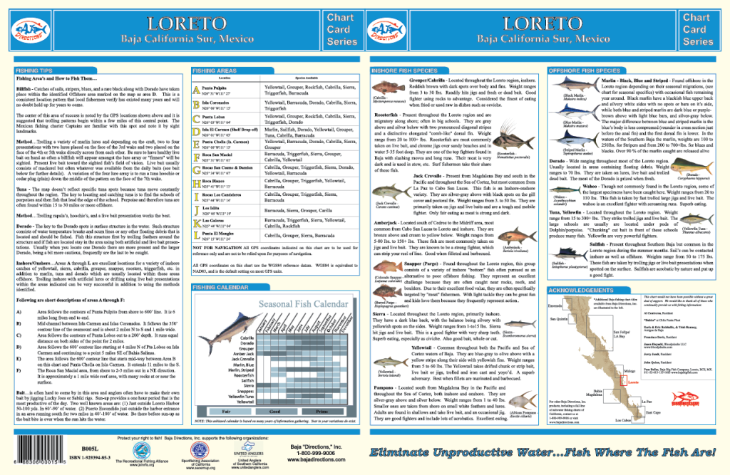
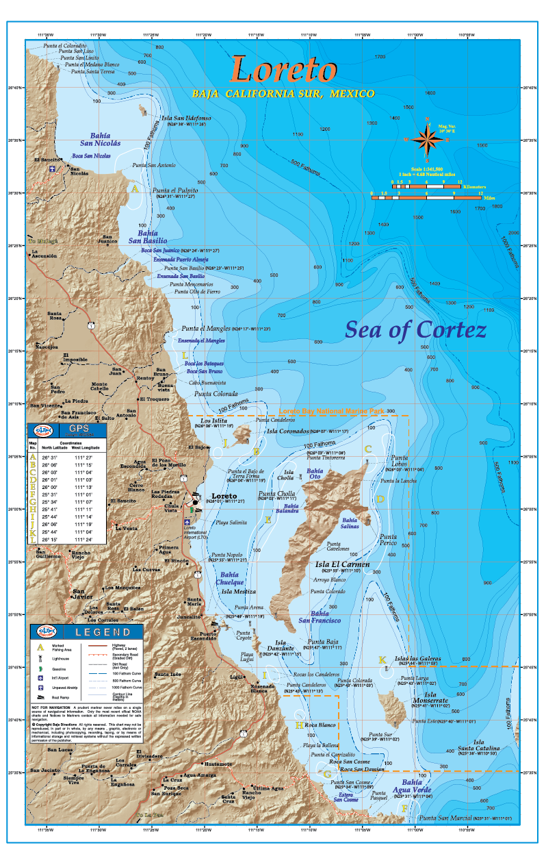 With official data from the government of Mexico, our fishing chart of the popular sportfishing destination of Loreto covers the fishing areas from 5 miles north of Isla San Ildefosnso to Punta San Marcial, including the waters off Loreto, Puerto Escondido, and water surroundung Isla El Carmen and Isla Monserrate. This chart features updated underwater contours (bathymetry), "3-D" land, road and facilities information along with popular fishing areas such as Roca Blanco, Punta El Pulpito and the fabled 100 fathom curve off Punta Cholla. The back side of the chart contains a great deal of information such as explanations on how to fish each highlighted area, GPS coordinates, a seasonal fishing calendar, fish identification chart, and much more. This full color, high-resolution map is currently available exclusively in our popular 11"x17" laminated format.
 -
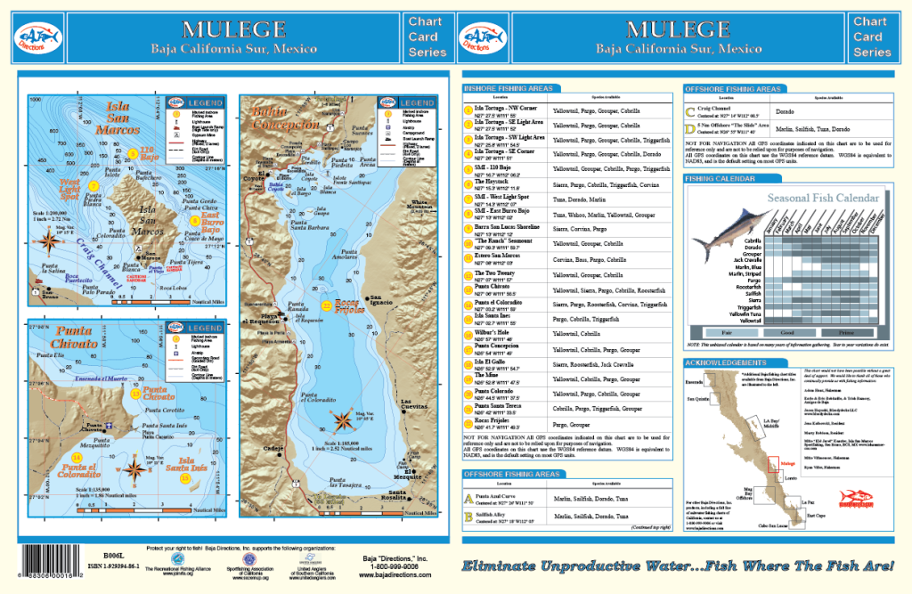
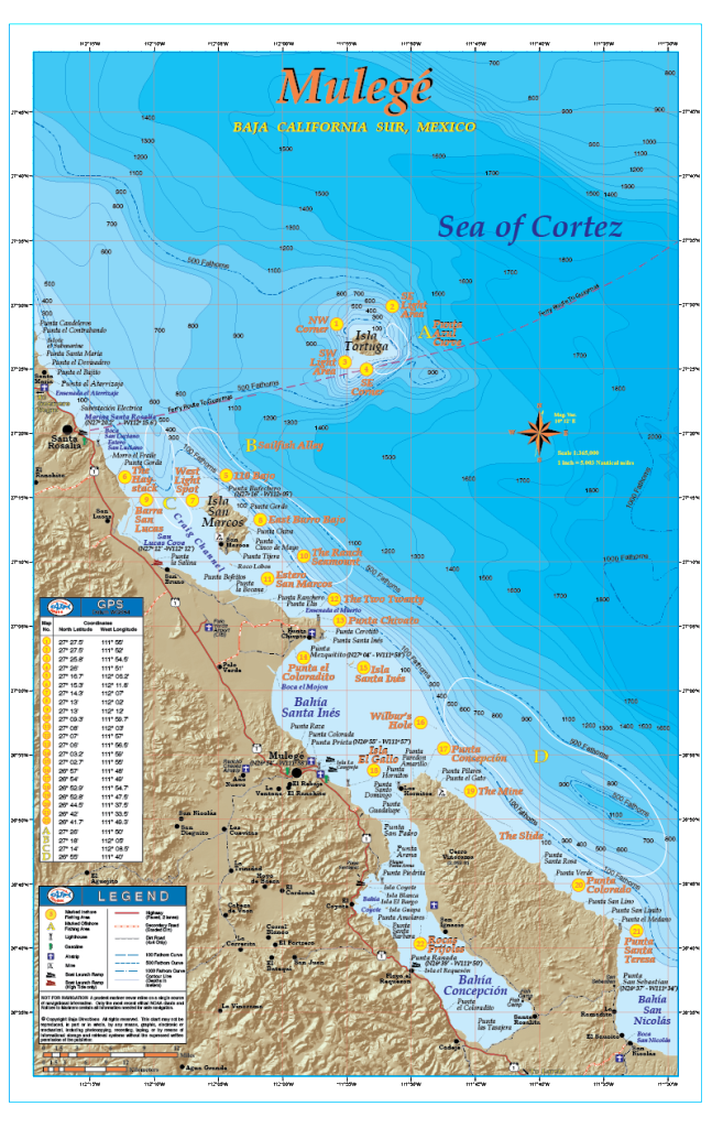 With official data obtained from the government of Mexico, our fishing chart of the sleepy sportfishing destination of Mulege covers the fishing areas accessible from Santa Roaslia, including Isla Tortuga and Isla San Marcos, south to Punta Santa Teresa - located some 30 miles down the coast from Punta Chivato. This chart in fact ends up overlapping our Loreto chart at Bahia San Nicolas. The title "Mulege" is definitely a misnomer however, as much effort has been given to incorporate fishing information for areas directly accessible from Santa Rosalia, San Lucas Cove, Punta Chivato and Bahia Concepcion, as well as from Mulege. Our Mulege chart features updated underwater contours (bathymetry), "3-D" land, road and facilities information along with popular inshore and offshore fishing areas such as the 110 Bajo off the north tip of Isla San Marcos, the Haystack just north of San Lucas Cove and the fabled Punta Azul Curve at Isla Tortuga. The backside of the chart has large-scale individual charts of Isla San Marcos, Punta Chivato and Bahia Concepcion, as well as a seasonal fishing calendar. This full color, high-resolution chart is currently available exclusively in our popular 11"x17" laminated format.
 -

 Our La Paz chart covers the fishing areas from Punta Coyote to just South of the Isla Cerralvo, including Bahia de La Paz, and the waters off Isla Espiritu Santo, Isla La Partida, and Isla Cerralvo. This chart features updated underwater contours (bathymetry), "3-D" land, updated road and facilities information along with popular fishing areas such as: El Bajo, El Charro Seamount, 88 Bank (a.k.a. Ocho-Ocho), Bajo San Lorenzo and Punta Arena. Also, the 100 and 500 Fathom Curves are highlighted so you can easily find the offshore "bluewater" and stay on those pelagic game fish. The back side of the chart contains a great deal of information such as explanations on how to fish each highlighted area, GPS coordinates, a seasonal fishing calendar, fish identification chart, and much more. This full color, high-resolution chart is currently available exclusively in our popular 11"x17" laminated format.